* This would make it the ninth consecutive above-average hurricane season.
* 20 named storms (winds of 39 mph or higher)
* 9 could become hurricanes (winds of 74 mph or higher)
* 4 major hurricanes (category 3, 4 or 5 with winds of 111 mph or higher).
“Early preparation and understanding your risk is key to being hurricane resilient and climate-ready,” said Secretary of Commerce Gina M. Raimondo. “Throughout the hurricane season, NOAA experts will work around-the-clock to provide early and accurate forecasts and warnings that communities in the path of storms can depend on to stay informed.”
The increased activity anticipated this hurricane season is attributed to several climate factors, including the ongoing La Niña that is likely to persist throughout the hurricane season, warmer-than-average sea surface temperatures in the Atlantic Ocean and Caribbean Sea, weaker tropical Atlantic trade winds and an enhanced west African monsoon. An enhanced west African monsoon supports stronger African Easterly Waves, which seed many of the strongest and longest lived hurricanes during most seasons. The way in which climate change impacts the strength and frequency of tropical cyclones is a continuous area of study for NOAA scientists.
“As we reflect on another potentially busy hurricane season, past storms — such as Superstorm Sandy, which devastated the New York metro area ten years ago — remind us that the impact of one storm can be felt for years,” said NOAA Administrator Rick Spinrad, Ph.D. “Since Sandy, NOAA’s forecasting accuracy has continued to improve, allowing us to better predict the impacts of major hurricanes to lives and livelihoods.”
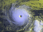
Tropical depressions, tropical storms and hurricanes are low pressure areas that develop in the tropical regions of the ocean (between 20 degrees N latitude and the equator). These storms are masses of thunderstorms that organize and begin to rotate. These systems, in order of intensity, are called depressions (winds between 25 and 38 mph), tropical storms (winds between 39 and 73 mph) and hurricanes (winds of 74 mph or greater).
The National Weather Service tracks these storms on charts during hurricane season, June 1 through Nov. 30, using the following symbols.
![]()
A tropical depression, the lowest intensity, is given a number once it has a counterclockwise spin and winds of 38 mph or less.

When wind speeds reach 39 mph and the storm is given a name from a pre-determined list, a tropical storm is born. While a tropical storm does not produce a high storm surge, its thunderstorms can still pack a dangerous and deadly punch. In 1972, Agnes was only a tropical storm when it dropped torrential rains that led to devastating floods in Pennsylvania, Maryland and Virginia. Sixteen people died in Virginia and damage was estimated at $222 million.

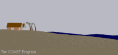
A hurricane is the most intense tropical event, with five categories and winds ranging from 74 mph to 155 mph or greater. Storm surge is a major concern with hurricanes. The extremely high winds cause ocean water to pile up, creating higher than normal sea levels with waves up to 40 feet in open water. High sea levels and shallow waters can devastate a coastline and bring ocean water miles inland.
A hurricane's bands of thunderstorms produce torrential rains and sometimes tornadoes. A foot or more of rain could fall in less than a day, causing flash floods and mudslides. Large rivers in the hurricane's path might still be flooding for days after the storm has passed. The storm's driving winds can topple trees, utility poles and damage buildings. Communication and electricity might be lost for days and roads are often impassable due to fallen trees and debris.
The Saffir-Simpson Hurricane Scale is a 1-5 rating based on the hurricane's present intensity. This is used to give an estimate of the potential property damage and flooding expected along the coast from a hurricane landfall. Wind speed is the determining factor in the scale, as storm surge values are highly dependent on the slope of the continental shelf and the shape of the coastline, in the landfall region. Note that all winds are using the U.S. 1-minute average.
Category 1 Hurricane
Winds 74-95 mph (64-82 kt or 119-153 km/hr). Very dangerous winds will produce some damage: Well-constructed frame homes could have damage to roof, shingles, vinyl siding and gutters. Large branches of trees will snap and shallowly rooted trees may be toppled. Extensive damage to power lines and poles likely will result in power outages that could last a few to several days. Hurricane Lili of 2002 made landfall on the Louisiana coast as a Category One hurricane. Hurricane Gaston of 2004 was a Category One hurricane that made landfall along the central South Carolina coast.
Category 2 Hurricane
Winds 96-110 mph (83-95 kt or 154-177 km/hr). Extremely dangerous winds will cause extensive damage: Well-constructed frame homes could sustain major roof and siding damage. Many shallowly rooted trees will be snapped or uprooted and block numerous roads. Near-total power loss is expected with outages that could last from several days to weeks. Hurricane Frances of 2004 made landfall over the southern end of Hutchinson Island, Florida as a Category Two hurricane. Hurricane Isabel of 2003 made landfall near Drum Inlet on the Outer Banks of North Carolina as a Category 2 hurricane.
Category 3 Hurricane (major)
Winds 111-129 mph (96-112 kt or 178-208 km/hr). Devastating damage will occur: Well-built framed homes may incur major damage or removal of roof decking and gable ends. Many trees will be snapped or uprooted, blocking numerous roads. Electricity and water will be unavailable for several days to weeks after the storm passes. Hurricanes Jeanne and Ivan of 2004 were Category Three hurricanes when they made landfall in Florida and in Alabama, respectively.
Category 4 Hurricane (major)
Winds 130-156 mph (113-136 kt or 209-251 km/hr). Catastrophic damage will occur: Well-built framed homes can sustain severe damage with loss of most of the roof structure and/or some exterior walls. Most trees will be snapped or uprooted and power poles downed. Fallen trees and power poles will isolate residential areas. Power outages will last weeks to possibly months. Most of the area will be uninhabitable for weeks or months. Hurricane Charley of 2004 was a Category Four hurricane made landfall in Charlotte County, Florida with winds of 150 mph. Hurricane Dennis of 2005 struck the island of Cuba as a Category Four hurricane.
Category 5 Hurricane (major)
Winds greater than 157 mph (137 kt or 252 km/hr). Catastrophic damage will occur: A high percentage of framed homes will be destroyed, with total roof failure and wall collapse. Fallen trees and power poles will isolate residential areas. Power outages will last for weeks to possibly months. Most of the area will be uninhabitable for weeks or months. Only 3 Category Five Hurricanes have made landfall in the United States since records began: The Labor Day Hurricane of 1935, Hurricane Camille (1969), and Hurricane Andrew in August, 1992. The 1935 Labor Day Hurricane struck the Florida Keys with a minimum pressure of 892 mb--the lowest pressure ever observed in the United States. Hurricane Camille struck the Mississippi Gulf Coast causing a 25-foot storm surge, which inundated Pass Christian. Hurricane Andrew of 1992 made landfall over southern Miami-Dade County, Florida causing 26.5 billion dollars in losses--the costliest hurricane on record. In addition, Hurricane Gilbert of 1988 was a Category Five hurricane at peak intensity and is the strongest Atlantic tropical cyclone on record with a minimum pressure of 888 mb.
2022 Alex |
2023 Arlene |
2024 Alberto |
2025 Andrea |
2026 Arthur |
2027 Ana |
Know if you live in an evacuation area. Know your home's vulnerability to storm surge, flooding and wind. Have a written plan based on this knowledge.
At the beginning of hurricane season (June 1st), check the supplies for your disaster supply kit, replace batteries and use food stocks on a rotating basis.
During hurricane season, monitor the tropics.
Monitor NOAA Weather Radio. It is an excellent / official source for real-time weather information and warnings.
If a storm threatens, heed the advice from local authorities. Evacuate if ordered.
Execute your family plan.
A HURRICANE WATCH issued for your part of the coast indicates the possibility that you could experience hurricane conditions within 36 hours. This watch should trigger your family's disaster plan, and protective measures should be initiated, especially those actions that require extra time such as securing a boat, leaving a barrier island, etc.
A HURRICANE WARNING issued for your part of the coast indicates that sustained winds of at least 74 mph are expected within 24 hours or less. Once this warning has been issued, your family should be in the process of completing protective actions and deciding the safest location to be during the storm.
The Atlantic hurricane season runs from June through November.
During that period be aware of your area’s evacuation routes especially at risk for a major storm. You can obtain maps from your states vehicle transportation department.
Blackmore WX METAR |
) |
Local RADAR Loop |
) |
Southern Plains Loop |
) |
Gulf Coast Loop |
) |
National RADAR Loop |
) |
Jet Stream Loop |
) |
GOES-East SAT |
) |
Weather Alerts |
Click Here to subscribe to Blackmore Weather Station Local Weather Alerts |
Lightning Alerts |
Click Here to subscribe to Blackmore Weather Staiton Thunderstorm Warnings and receive local thunderstorm warnings via email. |
Support Us |
Website Scanner |
|
| Scan Now Site Now! Scan will take a few mintues |
SSL Certificate |
 |